The ongoing threat of climate change has reinforced the need to measure river flow rates accurately. Today, river flow (also known as streamflow) can be monitored remotely using Internet of Things (IoT) sensors that measure both water velocity and level. This technology provides real-time insights and alerts—even from the most remote environments.
Key points
- Accurate Measurement: IoT sensors can accurately measure river flow (or streamflow).
- Essential Parameters: Stream stage, velocity, and depth/width are required to calculate the flow rate.
- Versatility: Monitoring can be conducted on both gauged and ungauged catchments.
- Power Options: Sensors can operate on battery, solar, or mains power.
- Sensor Types: Both submersible and surface-mounted sensors (e.g. radar) are available.
- Data Transmission: Data can be transmitted via 4G, LoRaWAN, or satellite.
- Wide Application: Sensors can be deployed in streams, creeks, or large-scale river networks.
- Data Accessibility: Collected data can be visualised, downloaded, and analysed from the cloud.
Why measure river flow (streamflow)?
Measuring river flow and streamflow are important for several reasons:
- Flood Monitoring: Generate timely alerts during flood conditions.
- Water Management: Avoid low water levels and manage drinking and irrigation supplies.
- Wildlife Conservation: Regulate flow to ensure the survival of aquatic wildlife.
- Infrastructure Management: Monitor and manage hydraulic structures such as irrigation systems.
How is streamflow measured?
Accurate streamflow measurement requires the calculation of several parameters:
- Stream stage
- River velocity
- River depth and width
These can be obtained manually or through the use of sensors.
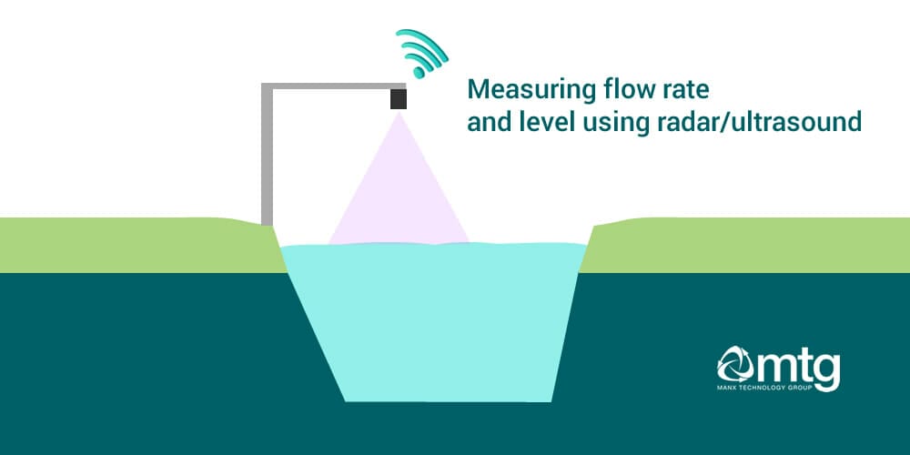
Stream stage
The height of the water surface above the stream bed. Traditionally, this is measured using a staff gauge, which can be prone to human error and lacks continuous data. Modern river level sensors, however, can record readings at set intervals. Modern river level sensors can accurately monitor levels.
River velocity
Historically measured using a mechanical current meter (a turbine-like device with metal cups). This method provides only periodic measurements. Today, radar-based surface velocity sensors, which utilise the Doppler effect, offer a non-contact alternative for continuous measurement.
River depth and width
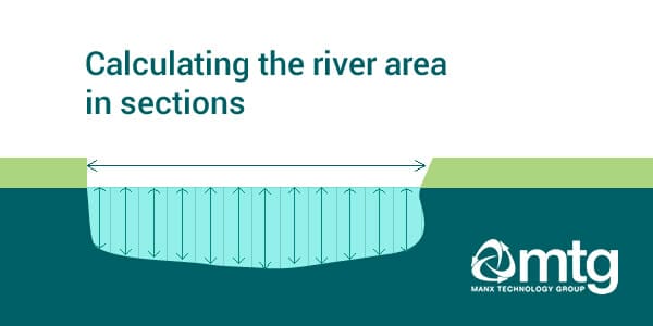
These dimensions are essential for calculating the cross-sectional area of the river. In uniform stream gauges such as weirs or culverts, calculations such as the Cipolletti formula may be applied. For non-uniform (ungauged) catchments, the river can be segmented, with each section’s area calculated individually.
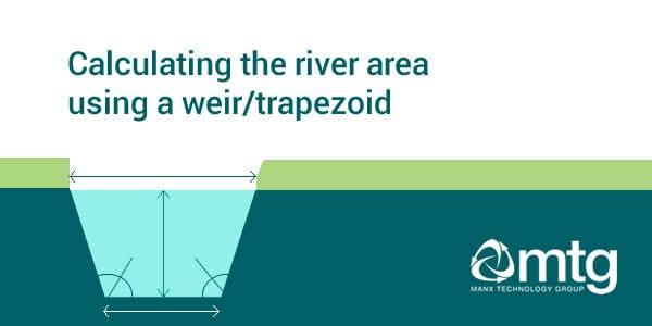
Gauged catchments, weirs and culverts
One of the constraints of river flow monitoring is that accurate monitoring can only be done in uniform stream gauges. These gauges are often in the form of a culvert or weir, where (depending on the shape) you can apply different calculations (i.e. Cipolletti calculations). These are known as gauged catchments.
- Gauged Catchments: These are typically found in uniform stream gauges, often in the form of a culvert or weir. Standard calculations (e.g. Cipolletti) can be applied here.
- Ungauged Catchments: Without a weir, the river must be divided into subsections. By measuring the length and height of each segment, you can determine the area and subsequently calculate the flow rate.
River area calculations
The streamflow rate (discharge) is ultimately calculated by multiplying the river area by the velocity, yielding a measurement typically expressed in cubic feet per second (or cubic metres per second, as appropriate).
River flow sensors types
Ultrasonic Distance Level Sensors
Ultrasonic sensors emit high-frequency sound waves (typically around 42 kHz, inaudible to humans) toward the river surface. By measuring the time taken for the sound to reflect back from the water, the sensor determines the distance between the installation point and the river surface. When the river’s depth is known, any change in this measured distance indicates a rise or fall in river level. To conserve battery life, these sensors are often configured to sample every 15 minutes, although intervals can be reduced in high flood-risk areas.
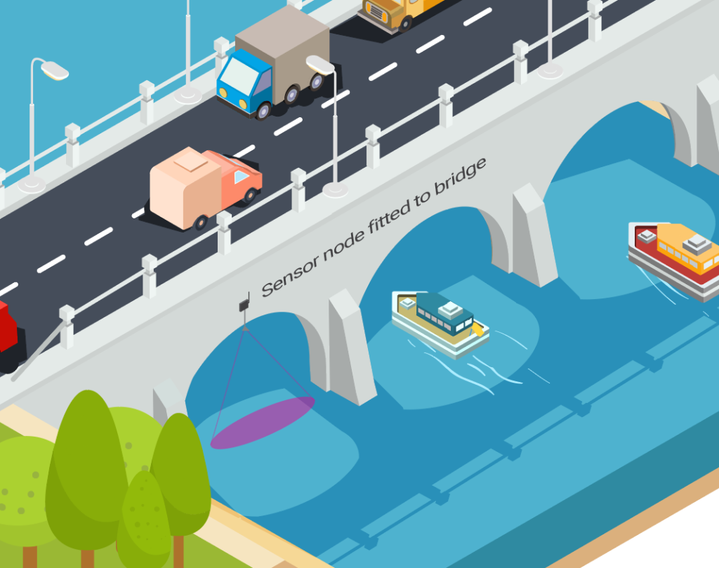
Radar Surface Velocity Sensors
Non-contact radar sensors are mounted above the river to measure surface velocity using the Doppler effect. They detect radiation reflected from the moving water surface and calculate the velocity based on the frequency shift. These sensors can be combined with distance level sensors in a single package, providing a compact and effective river flow monitoring solution.
Data transmission
Data from the sensors can be transmitted using one of the following technologies:
This multi-modal approach ensures that remote river flow monitoring is possible in urban, rural, and extremely remote areas. Once transmitted, the data can be visualised through web dashboards or apps and downloaded for further analysis. Integration with GIS or other similar systems is also possible for organisations that require it.
Further information
I hope this article has clarified the basics of river flow monitoring using IoT. I regularly engage with clients worldwide who are interested in both river level and streamflow monitoring. If you would like to learn more about our range of solutions and how we can assist, please do get in touch.
Useful Links:
- River level monitoring with IoT: Manx Technology Group (manxtechgroup.com)
- Internet of Things (IoT) Applications: Smart Water: Manx Tech Group
- Hydrometry: measuring the flow rate of a river, why and how? – Encyclopedia of the Environment (encyclopedie-environnement.org)
- How Streamflow is Measured (usgs.gov)